
Overview
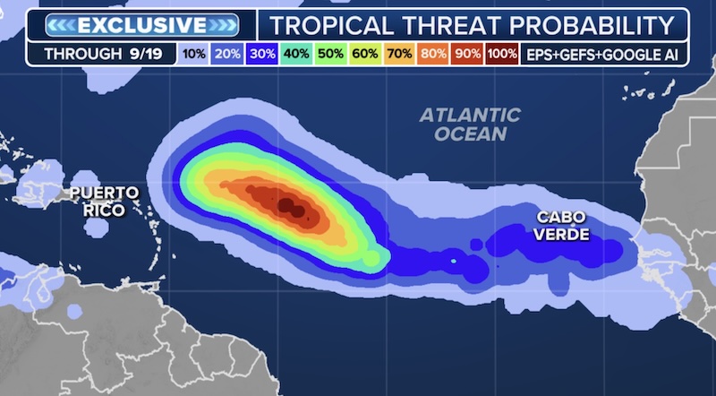
The Atlantic Basin is currently experiencing an unusual lull in tropical storm activity, despite being at the peak of hurricane season. A tropical wave emerging off the coast of western Africa has caught the attention of the National Hurricane Center (NHC) for potential development, but overall conditions remain hostile for strong storms.
Current Tropical Wave Activity
Location: A tropical wave is producing showers and thunderstorms just off western Africa.
Development Potential: The NHC has assessed a medium chance (50%) for this system to develop into a tropical depression by mid to late next week.
Limiting Factors: The wave is currently encountering dry and stable air, primarily due to Saharan dust, which reduces moisture and hampers storm formation.
Meteorological Insights
Haley Meier (FOX Weather Meteorologist): Points out that Saharan dust can decrease moisture levels by about 50%, which is detrimental for tropical storm development.
Bryan Norcross (FOX Weather Hurricane Specialist): Notes that while there is uncertainty regarding when the system will develop a circulation, many models suggest it could eventually become a hurricane.
Potential Path and Impact
The system is expected to move north towards the Caribbean over the coming days.
Uncertainty in Forecasts: There are diverging computer model predictions; some suggest the system could become Tropical Storm or Hurricane Gabrielle, while others indicate it may remain in the central Atlantic.
Impact Timeline: If the storm were to affect the northeastern Caribbean, it would likely be next weekend. Residents are advised to stay updated on forecasts.
Current State of the Atlantic
The Atlantic has seen a significant lull in storm activity, reminiscent of last year’s late summer pause.
Hurricane Erin: The only hurricane to form so far, reaching Category 5 status while remaining far from U.S. shores.
Factors Limiting Development
Reduced Thunderstorm Activity: Below-average rainfall in Africa has resulted in less thunderstorm activity, with the Intertropical Convergence Zone (ITCZ) shifting north.
Ocean Temperatures: While ocean temperatures in the Main Development Region are warm, they have not been sufficient to counteract poor atmospheric conditions.
Atlantic Niña: A pool of cooler waters off the African coast, known as “Atlantic Niña,” is also inhibiting storm development.
Future Outlook
Vertical Instability: Below-average vertical instability has been noted, reducing thunderstorm growth in the main development region.
Central American Gyre: Forecasters are monitoring the return of the Central American Gyre, which can lead to heavy rainfall and aid in tropical cyclone formation. The Climate Prediction Center has highlighted this area for potential development into mid to late September.
Conclusion
While the Atlantic remains relatively quiet, there are signs that conditions may improve for storm development in the coming weeks. Residents in the Caribbean and surrounding areas should stay vigilant and keep abreast of updates as the season progresses.