
Overview
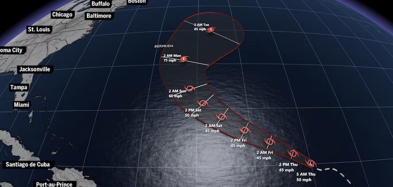
Tropical Storm Gabrielle formed in the Sargasso Sea early Friday Eastern Time, as reported by the National Hurricane Center. This marks the seventh named storm of the Atlantic hurricane season for the year 2025.
Current Location and Forecast
Location: Gabrielle is currently situated approximately 943 miles southeast of Bermuda.
Forecast Wind Speeds: The maximum wind speed forecasted for Gabrielle is 103 mph.
Intensity Predictions: Forecasting the storm’s intensity remains complex, with models showing potential for both strengthening and weakening.
Risks Associated with Gabrielle
Rip Currents
Rip currents, even from distant storms like Gabrielle, pose significant risks, being the third-highest cause of hurricane-related deaths after inland flooding and storm surges.
The Hurricane Center has begun providing forecasts for rip current risks, with data available only for U.S. coastlines.
Satellite Imagery Analysis
Satellite images are utilized to assess the storm’s strength, size, and structure. A well-defined, symmetrical eye indicates a strong storm that is not being hindered by external factors.
Atlantic Hurricane Season Context
The Atlantic hurricane season runs from June 1 to November 30. The National Oceanic and Atmospheric Administration (NOAA) initially predicted an above-average season with 13 to 19 named storms, later revising this to 18 named storms.
In comparison, last year’s season saw 18 named storms, with 11 developing into hurricanes, including two Category 5 hurricanes.
Climate Influences on Storms
This year’s hurricane season has seen a slow start, attributed to below-average ocean heat content in the primary storm formation regions.
Experts predict a high probability of a major hurricane making landfall in the U.S. this season, with climate change contributing to the increased intensity and rainfall capacity of storms.
Historical Context
Last year was one of the costliest for hurricanes, with damages exceeding $113 billion and over 250 fatalities.
Recent administrative changes have led to reduced staffing at agencies responsible for disaster response, which may impact future preparedness and response efforts.
Additional Data and Sources
The advisory includes tracking maps, intensity charts, and wind arrival tables generated from National Hurricane Center data.
Rip current and precipitation data are sourced from the National Weather Service and NOAA.

This patriotic themed short sleeve shirt is made of cotton, which is soft, skin friendly and has a delicate touch. It is not only durable and resistant to wear, but also highly breathable, keeping your skin dry and comfortable even in the hot summer.